

Located in central Cairo's Tahrir Square, the Egyptian Museum is a treasure trove of antiquities and a must see when visiting this sprawling, historic and culturally dynamic city. So when the opportunity presented itself to visit this museum, our team jumped at the chance despite the challenges. And by challenges, I mean that from the Cairo Hilton, we had to navigate a phalanx of guards, maze of concrete barricades, pesky street hawkers, and gypsy taxi drivers. This, followed immediately by a hair raising game of real-life Cairo Frogger. Drivers here are keenly interested in demonstrating how close they can come to side swiping jaywalkers at high rates of speed while not actually connecting. The whole trip from hotel to museum takes a hectic ten minutes. Between Jon, Chris and I this involves five near-death experiences, fifty extremely loud curses and twenty grey hairs. Finally, we arrive in a sweaty, frazzled cluster at the main gate of the Egyptian Museum. There, we buy a foreign ticket for ten times as much as the local equivalent and swat off another locust wave of inistent street vendors before safely making the confines of the museum grounds.


After passing the main gate, we find ourselves immediately sucked in to taking pictures of this crazy sphinx-like statue and other unique objects dotting the property. Snapping away, I was so mesmerized with these sculptures that I didn't even notice Jon and Chris talking with a dour, mopey-faced and poor postured middle-aged tour guide named Mohammed. By the time I do see what is happening and run over, it's all but too late.
"If you do not like my tour my friends, I do not deserve payment."
I hesitate, unconvinced. Jon and Chris do not. "Let's do it! It'll be fun!"
"Yeah. Great." As the only one of the three with Egyptian cash, my gut feeling, the knowing smirks on Jon's and Chris' faces and their snickers all point to me inheriting the responsibility of paying for Mohammed once we are through.
At the very least though, I figured that this cartoon character of a tour guide with close resemblance to Sad-Sack could at least walk us through the museum and explain in detail what objects we were looking at when we asked. But now, months later while reflecting on this experience, I wonder if it was actually Mohammed who got more than he bargained for. How many times would he regret approaching us in the courtyard? Did he end up as stressed in dealing with us as we did in crossing that insane street? In retrospect, he likely earned every Egyptian Dinar that we paid him.

Walking in to the Museum is quite literally like a scene out of an Indiana Jones movie. The doors open. A breath of partially stale, cool air blows past us. An endless waves of three thousand year old statues in countless shapes, colors, forms and sizes designed to replicate Egyptian gods like Horus and Isis stretch as far as the eye can see. Our awestruck, speechless excitement only extends for a few minutes before a slew of questions come to mind. And that, is when we finally accept that Mohammed isn't a top shelf guide. Or even a basic guide. A guide, but that's about it. Above average English skills don't translate to above average museum history knowledge and while this building is quite literally chock-full of statues, scrolls, carvings and canopic jars from the time of the Pharoahs, we only stop at a fraction of these. Whizzing by dozens of others with no explanation, the ones we do stop at only generate extremely high level details.
At one point, we arrive at a giant marble sarcophagus that sits adjacent to an embalming table. "This my friends is the great sarcophagus of Tutmoses the 3rd who ruled from 2000 to 1970 BC and was found in a..."
I get distracted by something else next to where we are standing: "Hey Mohammed, is this an embalming table that was used to prepare mummies?"
"Yes..."
"Is this notch on the side to allow fluids to drain and a body to firm up while resting on natron?"
"Yes..." Pregnant pause followed by a funny look. Anything more? Any more details on this table that we could get? What secrets could Mohammed unlock for us and give us his knowledge into the minds-eye of Ancient Egypt life, culture and secret rituals?
"This my friends is the great sarcophagus of Tutmoses the 3rd who ruled from 2000 to 1970 BC and was found in a..."
Mohammed drones on and repeats exactly word-for-word what was clearly a memorized blurb for each highlighted item that he had remembered. After a few stops, we end up at this little side area that has a bunch of pets that were mummified.
"Hey Mohammed! Is that a falcon mummy??" Next to a neatly bundled, 10 inch long blob that is clearly a bird wrapped in gauze sits an index card with "mummified falcon" written on it.
"Yes..."
We are in the middle of receiving a rambling, memorized and fairly boring explanation of these little mummies when Chris looks over on the far wall and excitedly yells out "NO WAY!!" Jon and I spin around and burst out laughing. As we all know, Heiroglyphs are the ancient Eqyptian written language. A series of characatures and defined symbols that died out with the age of Cleopatra and weren't understood again until 1799 when the Roseatta Stone was discovered, each symbol stands for something. Largely, the symbol is cartoonish and speaks for itself based on what the image represents via an action drawing. But we wonder aloud with tears in our eyes if this particular Heiroglyph was drawn as an Ancient Egyptian sense of humor. What's that guy in the middle doing?

After taking a few covert pictures next to the hundredth "No Photographs" sign we pass, Mohammed stops. He looks at us for a long second. Then he says: "My friends, I just want you to know that while photos are strictly not allowed in the museum, I do not personally mind. The only thing I want you to understand is that if anyone stops you.. I did not have anything to do with it, or know you were taking photos." Score! We begin to happily snap away with abandon.
We soon end up at the "Royal Mummies Room"- aptly named for the great Pharoahs of old that have been yanked from their rocky tombs and are now on naked display here in casings closely controlled for special temperature and humidity settings. Some of the names are impressive- Ramses III, Queen Hatshepsut, Amenhotep IV. As we slowly meander around the room taking occasional pictures, Chris' cell rings. "Hello?" It's his wife, and he proceeds to tell her all about our day while leaning directly over, and three feet away from the face of a motionless and 2,500 year old Ramses. The two proceed to talk on and on as if he is staring at a computer screen, not the mummified face of one of the leading rulers of Ancient Egypt.
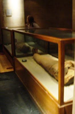


We soon end up at the "Royal Mummies Room"- aptly named for the great Pharoahs of old that have been yanked from their rocky tombs and are now on naked display here in casings closely controlled for special temperature and humidity settings. Some of the names are impressive- Ramses III, Queen Hatshepsut, Amenhotep IV. As we slowly meander around the room taking occasional pictures, Chris' cell rings. "Hello?" It's his wife, and he proceeds to tell her all about our day while leaning directly over, and three feet away from the face of a motionless and 2,500 year old Ramses. The two proceed to talk on and on as if he is staring at a computer screen, not the mummified face of one of the leading rulers of Ancient Egypt.


Then it hit me. Imagine going back in time to 1160 BC or so. Ramses the III is alive and well. The second Pharaoh of the Twentieth Dynasty, he has reigned for 25 years and during that time has expelled several foreign invaders, survived assassination attempts, led his people through famine, floods and economic hardships. In the eyes of his adoring people, he is considered a Living God. As a time traveller dressed in strange clothes, you tell Ramses this: In 3170 years, your shriveled body will be on display. Not in the tomb that you believe is your final resting place in Valley of the Kings, but in a strange building that will reside in a city that does not yet exist, near then present Memphis. Not the one in Tennessee. This new city, to be named Cairo, will go on to become the grand capital of the nation that his Empire laid the groundwork for.
One day, a group will arrive at this buiding, having come from beyond the oceans and where the sun hides at night. Even if Ramses wants to go where they are from, he would not be able to. It would take many, many years and require machines that are beyond his knowledge and comprehension, traveling through the air at tremendous speeds. They will have magic tools, too. Created out of new, strange substances these small, hand-held tools will glow from within. They will make strange noises, and the traveller who holds it will press a button. Immediately, he will be able to talk with his wife who lives across the world and in a strange, unrecognizable language. A transparent shield will keep these travellers from touching you in the box you are stored in, but they will still be able to see every part of you. While the travellers are staring down at your body, the one with the magic tool will ask his wife about how his son is doing and the plan to board another machine the next day to travel by air only 45 minutes down to Luxor, which typically takes a week via the Nile.
I tell you, it would be mind-blowing. I tell Chris about this and we both laugh. Mohammed grumbles something inaudible and mopes. Time to move on.
We continue deeper into the bowels of the Egyptian Museum. Passing wing upon wing of ancient pots, jars, figurines and carvings, it's easy to go into sensory overload. Books, scrolls and other parchment are stacked like dusty cord-wood next to shelves quite literally overflowing with three thousand year old stone dieties. All of this is so abundant that after the fifth wing, it all literally blends in to the background. There appears to be little organization here, although that's undoubtedly just to the naked eye. More likely, it's due to the fact that in a concentrated area of over five thousand years of unique and accessible history, there is just so much to be shown that it has to go somewhere. Five thousand! Five thousand. It's mind blowing. And as if that's not enough, we haven't even yet gotten to the masterpiece of the museum. Quite possibly one of the most archaeologically significant finds of history. One that's announcement spread across the world with electric speed, catapaulted the finder to worldwide fame and was so unique in it's treasure and historic value, that it transformed the way anthropologists understood the Ancient Egyptians forever.

In the grand scheme of things, Tut was a minor pharoah that died early in life and in his reign. His tomb in Valley of the Kings is overshadowed by much larger and more ornate ones and seems more like a broom closet than anything- three smallish rooms hastily carved out of bedrock that quickly erased off the contemporary map and the sands of time. Despite that, it's stunning how much was packed to the gills in these three minor chambers, and it all becomes evident in this museum where much of the 5,000 items are now on display. Much like what Howard Carter and his team unearthed in 1922, the further you travel down the Tut wing here, the more elaborate and amazing the items become. Painted wood items turn to metal. Metal turns to gold. Canopic jars turn to sarcophagus boxes, erected in a way very similar to matrushka dolls where Tut's remains were sealed in no fewer than ten gold, stone and wood protective boxes.


One day, a group will arrive at this buiding, having come from beyond the oceans and where the sun hides at night. Even if Ramses wants to go where they are from, he would not be able to. It would take many, many years and require machines that are beyond his knowledge and comprehension, traveling through the air at tremendous speeds. They will have magic tools, too. Created out of new, strange substances these small, hand-held tools will glow from within. They will make strange noises, and the traveller who holds it will press a button. Immediately, he will be able to talk with his wife who lives across the world and in a strange, unrecognizable language. A transparent shield will keep these travellers from touching you in the box you are stored in, but they will still be able to see every part of you. While the travellers are staring down at your body, the one with the magic tool will ask his wife about how his son is doing and the plan to board another machine the next day to travel by air only 45 minutes down to Luxor, which typically takes a week via the Nile.
I tell you, it would be mind-blowing. I tell Chris about this and we both laugh. Mohammed grumbles something inaudible and mopes. Time to move on.
We continue deeper into the bowels of the Egyptian Museum. Passing wing upon wing of ancient pots, jars, figurines and carvings, it's easy to go into sensory overload. Books, scrolls and other parchment are stacked like dusty cord-wood next to shelves quite literally overflowing with three thousand year old stone dieties. All of this is so abundant that after the fifth wing, it all literally blends in to the background. There appears to be little organization here, although that's undoubtedly just to the naked eye. More likely, it's due to the fact that in a concentrated area of over five thousand years of unique and accessible history, there is just so much to be shown that it has to go somewhere. Five thousand! Five thousand. It's mind blowing. And as if that's not enough, we haven't even yet gotten to the masterpiece of the museum. Quite possibly one of the most archaeologically significant finds of history. One that's announcement spread across the world with electric speed, catapaulted the finder to worldwide fame and was so unique in it's treasure and historic value, that it transformed the way anthropologists understood the Ancient Egyptians forever.

The Tutankhamun Wing is absolutely underwhelming at first blush. Tut treasures that were unearthed back in the 1920s look to be in the original display cases that Howard Carter plopped them in. Single pane glass connected with rickety wood frames stressed by decades of temperature and humidity extremes, they seem to barely hold their priceless content intact. The contrasts are stunning, actually. In many circles, the Tutankhamun treasure is hailed as the top discovery of all time- the only thing to top it would be discovering, say, the Holy Grail. Yet right here before our eyes and in plain view are ornate and intricate contents befitting a pharoah- throne chairs, urns, chariots, pikes. All haphazardly displayed in a side wing desperately in need of renovation and protected only by nominal security.
In the grand scheme of things, Tut was a minor pharoah that died early in life and in his reign. His tomb in Valley of the Kings is overshadowed by much larger and more ornate ones and seems more like a broom closet than anything- three smallish rooms hastily carved out of bedrock that quickly erased off the contemporary map and the sands of time. Despite that, it's stunning how much was packed to the gills in these three minor chambers, and it all becomes evident in this museum where much of the 5,000 items are now on display. Much like what Howard Carter and his team unearthed in 1922, the further you travel down the Tut wing here, the more elaborate and amazing the items become. Painted wood items turn to metal. Metal turns to gold. Canopic jars turn to sarcophagus boxes, erected in a way very similar to matrushka dolls where Tut's remains were sealed in no fewer than ten gold, stone and wood protective boxes.

Finally, we arrive at the treasure room- the inner sanctum of eye-popping, solid gold artifacts from Tut's reign. This room is dramatically different from we had passed through to get here. Restricted access. Cameras everywhere to protect the stunning contents. Bulletproof glass and a state of the art security system. On the wall before entering is another big, fat, bold sign in three languages reminding visitors that really, under no circumstances, are any photos allowed.
Solid cases that ring the room house carefully displayed gold amulets, knives and figurines which glitter and sparkle. At one side, two seven foot long, solid gold sarcophagus with inlaid stone and intricately shaped designs dedicated to the pharoah himself are made visible from all sides.
Solid cases that ring the room house carefully displayed gold amulets, knives and figurines which glitter and sparkle. At one side, two seven foot long, solid gold sarcophagus with inlaid stone and intricately shaped designs dedicated to the pharoah himself are made visible from all sides.

There, in the center of the room, is perched one of the most famous and recognizable works of art known to man- the glistening solid gold head mask of Tutankhamun. Lovingly shaped and formed from one piece of 24 karat gold, the burial mask which protected the head and shoulders of Tut as he traveled through the underworld for over 2,400 years is also accessible from all sides. The last time I saw this mask with my own eyes was in 1979 when the Tut treasure traveled through several select cities on a sold out tour in the United States. Our family went in to New York City to excitedly stand on a long bread line so we could catch a fleeting glance of the iconic head mask. In 17 weeks, 1.8 million people crushed together in the Metropolitan Museum of Art to take a look. It was a vastly different experience from what we found in Cairo. Here, no more than five others are even in the entire wing. What a stark contrast.


I start taking stealth pictures from the hip. Given the abundance of security cameras here and others in the room, it seemed better to show at least some discretion. Mohammed knows we are going to go for it, and probably for that reason decided to stay outside the treasure room. If we got into trouble, at least he can claim plausible deniability. Some turn out, most don't. But I definitely want to get some pics of this room and it's content so I continue to snap away. Out of the corner of his eye, Chris sees me and walks over.
"Whatcha doing?"
"Taking pictures"
"From the hip? Here give me that" and takes my point & shoot. Chris then walks right up to Tut's head mask and from a foot away, holds the camera out at arms length and takes a picture. I'm expecting some sort of security team to immediately descend on us, an alarm to go off, an intercom to scream to life. At the very least catch some sort of serious ass chewing from another museum-goer. Nothing.. just silence.
"No way, that's freaking awesome" I say. With that, all three of us spread out and embark on picture taking across the treasure room with glee. The main focus of effort, of course is the head mask.
We take pictures of each other and together as we branch out across the room. A good five minutes later Chris pulls me aside and says "hey, get a picture of me behind the head mask."
"Sure." It comes out great.
"Dang that picture looks really cool. Ok, my turn- get the same one of me" I say. While I'm handing the camera over to Chris, we hear an extremely loud, authoritative and really, really angry voice:
"HEY!!!!''
Zoinks!! We look over to the doorway and see a team of guards walking extremely fast. Like.. MOVING. One is holding a walkie talkie and pointing at me with an extended arm and a really, really pissed look on his face. Eeep! I press down on the shutter button about ten times to take pictures of my leg, the floor and some side cases. Jon, who is on the other side of the room looks on wide-eyed and steers clear of Chris and I. Mohammed disappears initially, then peeks his head in like a "Kilroy Wuz Here" cartoon drawing after the four stream by.
The guards surround us. "NO PHOTOS!" the lead guard almost yells with spit coming out, jugular bulging, eyes piercing angrily.
"Oh, really? We didn't know. So sorry."
"Delete them now." The guard points at my camera quickly and firmly instructs.
"Ok, no problem. But this camera isn't very good, I'll show you." With that, I show him the first blurry and grainy hip-shot picture that pops onto the screen. The guard becomes much more relaxed. I delete it, and the next blurry shot of the museum floor pops onto the screen.
"Ok my friend. Do not take any pictures in this museum. It is not allowed." He softens his approach. The guards spin around on their heels and begin to walk away. We apologize again. Jon begins to laugh. We still have the pictures, and somehow are still allowed to stay in the treasure room, surrounded by all the priceless objects we have just been liberally photographing.
Mohammed is waiting for us outside the treasure room. He shakes his head and mutters something as we move on. I jam the camera deep into my pocket and don't take it out again. I want to make sure we get out with both my camera and these amazing pictures. We talk about all of the unique things we have seen in this museum and how close a call we just had.
"Hey Mohammed, do you think the inside of an Egyptian jail looks like the inside of King Tut's tomb?
"Yes.."

Back to Main Page: http://www.landtarget.blogspot.com/
 S
S


